 So it was just too nice, and thunderstorms were predicted for the weekend, so on Friday May 30 I decided to do another century.
I decided to head south again, but via a different route. I went up out of Ithaca via Cornell's campus, to Varna, and from there along Rts 366 and 13 into Dryden. At Dryden I turned south onto Rt.38 and rode all the way to Owego. 38 goes through a kind of valley, though it is rolling hills, and also goes through the villages of Harford, Richford, Berkshire, and Newark Valley.
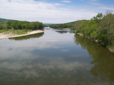
Downhill into Owego where 38 hooks up with 96, and into downtown Owego. Turning right and then following Rt 17c, which is also Bike Route 17 out of Owego. I have to say, Bike Route 17 is one of the worst routes in terms of bike-ability. The shoulder is almost nonexistent in places, and in other places it's totally broken up. Though 17c goes along the Susquehanna, it's not down at river level and is in fact hilly. I followed 17c to Rt 282 crossing of the Susquehanna (see photo below), then right onto West River Rd.
I've since learned of an alternate route that I'll try next time: in Owego you cross the bridge, turn right onto Rt 434, and then left onto Stanton Hill Rd. You can either continue on Stanton Hill Rd to East River Rd, for about a 200 ft climb in half a mile -- the rest is pretty much downhill -- or else, you can turn left onto Sulfur Springs Rd. and then right onto Smith Creek Rd for a flatter ride.
Anyway, I continued on West River Rd, which crosses into Pannsylvania (Bradford County) just before Sayre. My googlemap directions gave the wrong name for a street, so instead of crossing the bridge that goes directly into Sayre, I ended up continuing and then crossing into Athens. I followed Main St and in Sayre stopped for a late lunch.
This was a mistake. I really should have stopped in Owego, at mile 44. Instead, I waited until Sayre, at mile 66. The results were telling. I'd had only a large milk shake in Richford, and was a bit dehydrated despite drinking regularly. So the stretch between Owego and Sayre, though relatively flat, was a slow stretch. At Sayre I stopped at a pizza place, had three slices of cheese pizza and a very large lemonade, which was great.
 Then, onward back into NY State, through Waverly, north to Van Etten, right onto 34 into Spencer and continuing on 34 back into Ithaca.
This was the flattest century ride I've done in the Finger Lakes region, with a total of about 3,000 ft of climbing (the very flattest one, with a total climb of 350 feet over 100 miles, was in the Niagara frontier region of Ontario). But my time wasn't the best, and was actually slower than the century ride I'd done the week before, which had about 250 more feet of climbing.
Anyway, this was nevertheless a great ride, and I'll definitely be doing this century ride again!
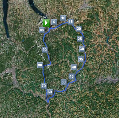
Route: Ithaca-Varna-Dryden-Owego-Sayre-Spencer-Ithaca
Total distance: 104.04 miles
Ride time: 7:01'56
Avg speed: 14.79 mph
Total time: 8:50am-4:55pm, 8 hrs, 5 mins
Total climb: 2998 ft
Low point: 390 ft, Ithaca
High point: 1313 ft, Rt 38 three miles S of Dryden
Avg climb: 28.82 ft/mile
Consumed: 1 large vanilla shake, three or four chewy granola bars, 32 ounces of Gatoraid, a few liters of water, one coffee, 32 ounces of lemonade, 3 slices cheese pizza.

No comments:
Post a Comment