On South Danby Rd south of IthacaMy goal for 2009 is 18 century rides. I didn't think I'd make it, since I didn't get in as many as I'd planned over the summer. But then it looked like the weather on Monday would be perfect, and since it was my birthday I thought I'd give myself a present of a century ride -- it would be #17, so with the December century ride I'd make my goal.
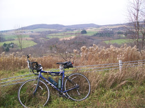
I decided to ride a very hilly route I'd gotten from Mark Frank of the Rochester Bike Club, called the Honeypot Hilly Hundred, with about 8,000 ft of climbing (I'm a bit behind on my climbing goals too...) So on that bright and sunny November morning, with the temps in the 50s already by 8am, I took off. It was nice wearing only bike shorts, a shirt and light biking jacket.
The first climb was up Coddington and then onto Troy, onto Nelson and then down Steamhill to 96b. Then along 96b a bit until South Danby Road, another climb taking me down to Rt 96. A flat ride along 96 to Candor, then up Honeypot Rd, which I've done a number of times. At the end, turning right onto Old 76 into Speedville.
At this point I missed a turn, continuing along Old 76, but realized the mistake and turned back and headed up West Creek Rd. I was supposed to turn onto Glen, but turned instead on a road with no road sign, which turned out to be Rejmer, which eventually rejoined W Creek Rd, at which point I realized I'd made a mistake, so I asked someone how to get to Berkshire. She directed me onto Howard Hill Rd, which was a very nice climb, and brought me to Rt 38 at Newark Valley, so I followed 38 up to Berkshire. Fortunately the wind was from the south so this was the longest flat part of the route.
 At Berkshire I turned right onto E. Berkshire road for another climb, then up Hartwell Rd, Caldwell Hill Rd, crossing Rt 79 at Center Lisle, then up Hunts Corners Rd down to Rt221.
At this point I realized that to make it home by sunset, about 4:40, I'd have to change the planned route to keep my total at about 100 miles. By missing Glen Rd and ending up in Newark Valley, I'd added about 15 miles to the route, so I decided to cut off the part of the route that continued on to Marathon, and just turn on Rt 221 and then pick up the route again at Babcock Hollow Rd in Harford. Unfortunately this also cut out about 1000 feet of climbing.
Another problem was that Marathon is where the food was. I hadn't passed a single place to get water or food since I'd left Candor. Fortunately I'd brought 4 chewy granola bars and two water bottles, but I was getting hungry and by the time I hit Babcock Hollow Rd I was out of water. I hoped I'd make it to Dryden okay.
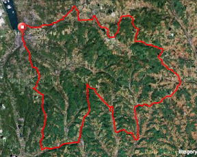 Babcock Hollow Rd starts out flat, following a creek, but then goes up in a nice big climb. The road is newly graded and paved, which is nice. It then hooks up to Daisy Hollow Rd, which is another big climb, then down again, where I picked up Lake Rd, into Dryden. At Dryden, about mile 85, I stopped for food - peanuts and poptarts - gatoraid (my face was encrusted with salt so I thought I should definitely top up my electrolytes) and water. After about 10 minutes I felt much better, and I took off for the last bit, up onto Ferguson, down Yellow Barn, to Johnson, into Freeville, and the very familiar return into Ithaca along Upper and Lower Creek and Hanshaw Rds.
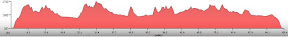
I got home a bit after 4, well before sunset. I felt good, and given the climbing -- 7100 feet -- I was happy with my time, 13.62mph, and climbing average of 70.35 feet/mile.
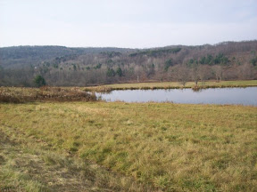
What a great day for a bike ride, and the route was excellent. I'll have to do the correct version of the route some other day. But this century ride was a great birthday gift to myself. It's nice riding in this late fall landscape, many shades of browns and grays, a few straggling leafs still in place, but having it be warm enough to be really enjoyable.
I'm also glad that I had enough left-over energy to go out for dinner with Lisa and Lucas that night, and to blow out the candles and open gifts later.
Route: Ithaca - Candor - Speedville - Berkshire - Harford - Dryden - Ithaca
Total distance: 101.21 miles
Ride time: 07:25:56
Avg speed: 13.62 mph
Total climb: 7,120 ft
Low point: 394 ft, Ithaca
High point: 1761 ft, on South Road, south of Caroline Center
Avg climb: 70.35 ft/mile
Total distance: 101.21 miles
Ride time: 07:25:56
Avg speed: 13.62 mph
Total climb: 7,120 ft
Low point: 394 ft, Ithaca
High point: 1761 ft, on South Road, south of Caroline Center
Avg climb: 70.35 ft/mile

3 comments:
You da man, birfday boy!
Hi Finger Lakes - I just browsed by and found your blog. I'm likewise 50ish and relatively new to biking. Your routes and descriptions are like wandering around my home stomping grounds! Drop over to the Wayward Home sometime.
By the way...18 centuries is just a tad much for me...I'm still working up to my first and the mountain bike is an endless distraction.
Hey WS, this is a great area to bike in isn't it?
Go for that first century! Mine was an organized one, the AIDs ride around Cayuga Lake, a great first century, incredibly well-supported.
Thanks for stopping by!
Post a Comment