Tuesday, July 29, 2008

Keuka Lake

I'll blog about my 3 July century rides later, but now I want to write about a great ride I did with the Southern Tier Bike Club this past weekend.

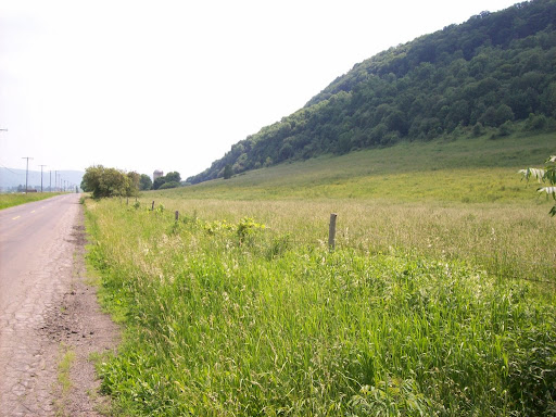
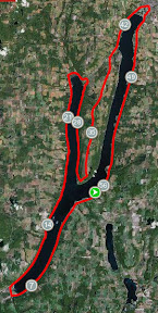
Keuka Lake is the really interesting-looking Finger Lake. Kind of like a tuning fork, it splits in the middle and has east and west branches (see photo at left).

I'd done the Keuka Lake ride a couple of times -- in fact it was my first "long" ride -- but I'd never done the climb up Skyline Drive to Bluff Point before. This club ride included that climb. I'd also met some of the STBC members at the Great Finger Lakes Bike Tour back in June, and they're cool folks, so my biking buddy Tommie and I decided to make the drive to Keuka.

We met up at the Switzerland Inn -- more about their back deck later -- and began the ride around 10:30am or so. The ride south into Hammondsport -- at the southern tip of the lake -- on Rt 54a is pretty easy; it's a smooth road, wide shoulder, flat and downhill.

We regrouped in H'port in the town square, then took off toward Branchport, at the NW tip of the west branch of the lake. After a stop and regrouping at the convenience store there, we took off for Keuka State Park, where some of the riders had camped the night before. We stopped there for some bananas and apples, then took off toward the bluff.

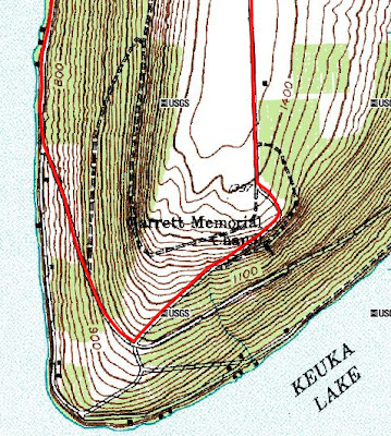
It wasn't really clear to me how steep this climb really was going to be. Some said it was the steepest thing they'd ridden, others that it was only 8-9%. I did check the topo map, but it's hard to imagine what climbs are actually like from the map.

We rode along the lake for a few miles, then the road started climbing a bit. The lake itself is at 720 feet, and the roadway was just a bit above the lake level. The first stage of the climb went up to 980 feet pretty gradually. Then, on the left, we came to Skyline Drive.

It looked steep from the bottom -- and it was. We started up the hill. It seemed to go on forever, though in fact the distance wasn't that great. The grade was often at 14-15%, the climb went from 980 feet up to 1400 feet. Now a climb of 420 feet isn't really that much -- my daily commute climbs 530 feet. But it's the distance that counts. My commute's climb is over a mile. This 420 feet climb was over a distance of about half a mile.

One of the riders on a mountain bike took off ahead of me and virtually raced up the hill. I just pumped away, wondering when the climb would end. But around every turn there was yet another big climb. The good thing is that most of the climb was shaded.

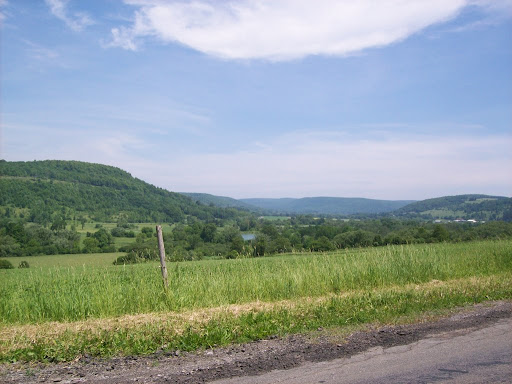
We got to the top and sat down, waiting for the others. The view from the top of the bluff was beautiful, and there was a really nice breeze up there. Once we regrouped -- and tasted some of the honey that ride organizer Steve had gotten along the way -- we headed down to Penn Yan, where we stopped at the McDonalds before heading back to the inn.

It was a great ride. I rode much of it with Doug, who kept up a really nice pace, which kept me pushing myself -- thanks Doug! By the time we got back to the Switzerland Inn, we were all ready for some liquid refreshments.

We got tables out on the back deck, in the shade, and enjoyed the lake breeze and a great view of the bluff -- it definitely doesn't look as steep as it is.

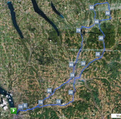
Route: Around Keuka Lake
Total distance: 59.33 miles
Ride time: 3:38'53
Avg speed: 16.26 mph
Total climb: 2184 ft
Low point: 720 ft, Hammondsport
High point: 1429 ft, crest of Skyline Drive

Avg climb: 36.81 ft/mile
Consumed: Lots of water, gatorade, an apple, a banana, large coke; at Switz Inn, 2 beers, lemonade, chicken sandwich, piece of pizza.

Thursday, July 24, 2008

Rain

Man has this been a rainy summer!

It started out okay, but for the past month, it's been raining several times a day. The radar map above is typical, though the gap between rain storms is a bit more than usual.

I biked all winter, so got used to biking in sub-optimal conditions. But those beautiful upstate NY sunny days we had earlier in the summer are such perfect biking weather, I got spoiled. I find my mood is great, my biking is great and overall I feel great when it's a beautiful sunny, breezy day. I know I need to just zen out and accept fate, but when rain clouds roll in it gets me down.

I've sort of figured out, based on the radar weather photos, how long I can go out without getting caught in a dowpour, but I don't always succeed. This past week I did a 40 mile ride, out to Locke then back via Groton. As I was headed toward Locke on Lamphier, I saw the gathering dark clouds. From the radar I knew what was coming -- a big storm. It was coming faster than I thought.

From Locke to Groton is about 6 miles. I went as fast as I could, and could feel the dark clouds chasing me. Just as I got across the Groton village line, I felt a few drops. Knowing I had only seconds before the downpour, I pushed myself to get to a coffee shop on Main St. I got there just as the downpour began. It was a huge one, sheets of water, strong winds, a real to goodness summer storm.

Unfortunately the coffee shop had closed, but the good thing is, it had an awning and a doorway, so I brought my bike into the doorway and hung out there for about 40 minutes until the rain had slowed to a drizzle. The ride home was fine, the storm passed and by the time I got to Freeville, another 6 miles down the road, the sun was out.

Yesterday I decided on a short, 22 mile ride, thinking I could squeeze it in between rain clouds. I started out on wet roads, then by the 11 mile mark they were dry, but on the way back in it started drizzling.

So this has been my life the past month or so, checking the weather radar, trying to figure out how far I can get without getting wet, waiting for the right opening... which I'm doing right now.

Here's the storm that's on its way, about to hit:
rain's coming I'm hoping the forecasts are right, and that it'll clear up this afternoon, after this coming storm -- which looks like a big one that'll last a while -- passes through. And then, they're promising a few sunny days.

I won't believe that until I've biked them.

PS as I finish this post, the big raindrops have started falling...

Late edit: So I ended up going out in what looked to be a big break in the rain. I headed north to Genoa, dry roads, no problem, the dark heavy rain clouds all to the east and headed away. But then, turning west on Rt 90 toward King Ferry I saw a rain storm. As I entered King Ferry the drops started, and I made it to the covered gas station there just as it downpoured. I waited for about 1/2 hour until it got down to a light drizzle, and took off south on 34b. It was good until Lake Ridge when it started raining, and it rained all the way until after Lansing. I got home very wet, and it turned out it had barely rained at all at home. . .

Saturday, July 12, 2008

June century ride

Better late than never... I'm a couple of centuries and a few interesting rides behind, so let me start to catch up.

On June 13 I did my June century. It was a really beautiful ride, with climbing and flats, and lots of beautiful rural scenery, both farms and woods.

I started out heading up to Dryden, which is a climb of almost 1000 feet total. I left Ithaca going up Devon Rd through Cayuga Heights, to Etna, up Etna Rd to Rt 13 and then to Dryden. From Dryden I continued on to Virgil, and then through Virgil to Cortland. The ride from Dryden to Cortland this way -- Rts. 392 and 215 -- has some nice climbs, 977 feet from Dryden to Cortland, and some beautiful views.

In Cortland, there's a short bit through some city streets, and I stopped for lunch downtown at a pizza place, but then it was on to East River Rd, along the east side of the east branch of the Tioughnioga River.

This is a beautiful, rural ride, rolling hills, great views (see photo at left). It ends up at Cheningo Rd. Turning left, in a few miles you hit Rte 13 at Truxton. After a right turn, a few hundred feet you turn again, left onto Rt 91 north. This is a really beautiful road, low traffic, brings you by Labrador Ski slopes but also through the "Labrador Hollow Unique Area," which is an amazing and very beautiful wooded area that's well worth a hike if you have the time. I'd just hiked it a few weeks earlier and so continued on to Apulia, where I turned right onto Rt 80, which I followed to Fabius. From Cortland to Fabius I'd climbed 900 feet over about 24 miles.

The route from Fabius to Pompey, following Rt 91 and then cemetery road, is another beautiful rural ride, ending in a big climb into Pompey -- total climb in the 5 miles from Fabius to Pompey was 500 feet, all pretty much in the last mile. It was a very hot and sunny day, temperature about 90 degrees or so, and I clearly recall pedalling slowly up the hill past the cemetery, sweat dripping, looking forward to the coming downhill.

From Pompey, I took Rt 20 west to Apulia Rd, which is a big downhill, then left onto Apulia, which is rolling hills, into Apulia itself, then right onto 80 into Tully, where I stopped for a milkshake and lemonade.

The ride from Tully to W. Cortland is very flat, and it went pretty fast. It's about 17 miles, and there's 250 feet of climbing, much of that at the very beginning. The first part, Long Rd and then Song Lake Rd, is very pleasant, low traffic, goes right by Song Mountain Ski slopes. Then it joins Rt 281, which has moderate traffic and a good shoulder. I was cruising along this section, though into headwinds from the S at 10-25mph so not as fast as I've done this in the past.

Also, mechanical problems: suddenly, right near Song Mountain, my shifters stopped working. I was in the highest gear in the back, so effectively only had three gears -- really only two, since the very highest gear was pretty useless. So I soldiered on, and learned that if I really push myself I can go faster than I thought I could.

I continued on from West Cortland, turning onto Luker Rd, then following McLean Rd and Fall Creek Rd back to Freeville, then onto Lower Creek and Upper Creek Rds, to Hanshaw, and back down Devon, retracing the start of my route.

Overall I was very happy with this ride, especially considering the heat, the winds and the shifter malfunction -- turns out the cable had broken inside the handgrip somehow...

Route: Ithaca-Dryden-Virgil-Cortland-Fabius-Pompey-Tully-W.Cortland-Ithaca
Total distance: 103.71 miles
Ride time: 7:10'33
Avg speed: 14.45 mph
Total time: 9:00am-5:40pm, 8 hrs, 40 mins
Total climb: 4606 ft
Low point: 390 ft, Ithaca
High point: 1757 ft, Rt 215 between Virgil & Cortland, near Congdon Lane

Avg climb: 44.41 ft/mile
Consumed: Two slices pizza, large lemonade, 1 large vanilla shake, three or four chewy granola bars, 32 ounces of Gatoraid, lots of water.