Wednesday, October 15, 2008

Hankering for hills


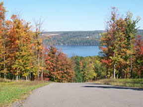
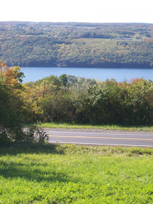
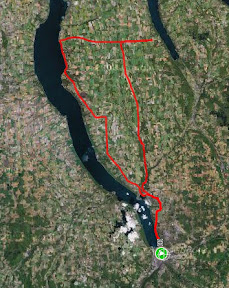
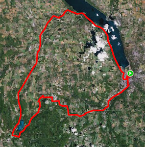
My Cayuta Lake loop: Cayuta Lake is the little lake in the lower left hand side of the photo. Connecticut Hill is the heavily forested area just east of Cayuta Lake
I like flat, smooth roads just as much as the next cyclist. I love to get going real fast, boosting my average speed and distance, and just cruising.

But sometimes I like to climb hills. I do the 530 feet climb on my commute to work in the morning, but this past week I wanted to do some good hill climbing, especially with the beautiful fall leaves.

So on Saturday I headed out and climbed up to Schaffer Rd in the Newfield back hills, stopped to pick apples with my wife (who drove up) at Little Tree Orchard, and continued on to Van Etten. The climb was great, as was the inevitable downhill. In the 6½ miles from where you turn onto Newfield Depot Rd from Rt 34, to the summit in North Van Etten, at 1845 feet, just north of the North Van Etten church, it's 1840 feet of climbing, for an average of 283 feet/mile.  The total climb for that ride was about 2400 feet, for an overall average of 55.6 ft/mile.


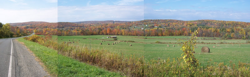
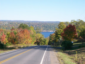
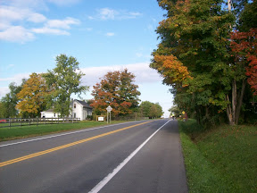
Panoramic view looking up Millard Hill Rd

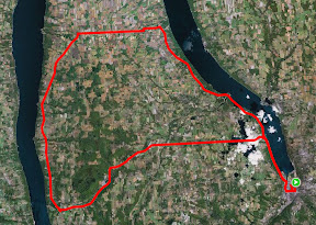
Yesterday afternoon I again headed for the hills. I wanted to do my Cayuta Lake loop, but decided to take a hilly way to the lake, via Connecticut Hill -- the highest point in Tompkins County, at 2099 ft. Unfortunately the roads that go the highest are all dirt roads, and I don't like to ride dirt roads on my road bike, especially on downhills, so I skirted the hill, taking the paved roads around the hill. The highpoint on these paved roads is 1814 ft.
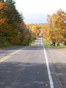

On Connecticut Hill Rd
The climb up from where Millard Hill Rd branches off from Rt 13 before Newfield is a beautiful one. Very little traffic, a relatively gradual climb up to the summit of 1814 ft, altogether over 6½ miles, 1840 feet of climbing -- an average of 283 feet/mile -- coincidentally exactly the same as Saturday's ride. The sun was out, it was windy, and as I got higher more and more trees had totally changed or else had already lost their leaves -- downtown there are still plenty of green leaves mixed with the reds and yellows and oranges.
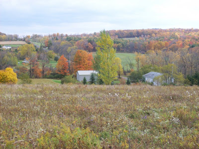

Trumbulls Corners, from Millard Hill Rd
After all that climbing the rest of the ride, on Co.Rt 6 and 10, and then state routes 228 and 227 into Trumansburg, and 89 back into Ithaca, were all relatively flat and pretty easy (except for that one big climb on 89...).  The total climb on this ride was 2636 feet, and the average climb was 51.4 ft/mile.

All in all these were great rides, and if you like beautiful vistas and some moderate climbing, these are great roads to ride.

Wednesday, October 8, 2008

Between the lakes


Cayuga Lake from Rt 89 at Seneca/Tompkins Co. line
Monday after work I went out for a ride. It felt chilly, the wind felt cold and I felt tired. The season of warm rides in shorts and t-shirts is over. I was feeling a bit down.

I checked the weather forecast for the next day: it was supposed to be a beautiful day. So I decided I'd do one of my favorite rides, what I call Between the Lakes. On Tuesday I got up early, finished up most of my work by early afternoon, and got going.   By the time I left it was pretty warm out, sunny, a beautiful fall day.

The Between the Lakes ride takes me up to Interlaken along the west side of Cayuga Lake, over to Lodi, down along the east side of Seneca Lake, to Burdett, and than back across to just north of Ithaca.

The start of the ride is the gradual uphill along Rt 89 from Ithaca up to the Cayuga Lake Creamery ice cream place at Interlaken.  I love this stretch, there are only a few significant uphills, and there are a few nice downhills, including down into Taughannock.  The views of Cayuga Lake are spectacular as you ride along the west side of the lake out of Ithaca, and then again later from higher points.


Cayuga Lake Creamery, on Rt 89
at Interlaken

Coffee ice cream cone
Of course I stopped at the Cayuga Lake Creamery (only three more ice creams and I get a free one!!) and got a double scoop of coffee ice cream.  From there I continued a bit down Rt 89 and turned left onto Rt 141 towards the village of Interlaken.  This is a pretty gentle climb, about 240 feet over a little more than a mile.

In Interlaken I turned left onto Rt 96, and after a couple of blocks, right onto Rt 96a, which you follow for about five miles into the village of Lodi.  This stretch is a good climb, but again pretty gradual, climbing from about 910 feet to 1240 feet just before Lodi, through mostly cornfields.  The last mile and a half is a downhill of about 140 feet down into the village.

Seneca Lake from Rt 414, vineyards in foreground
In Lodi, I turned left onto Rt 414, which goes along the east side of Seneca Lake.  This is wine country, and I biked by numerous wineries, vineyards, and restaurants.  414 has a nice shoulder, and is newly paved for most of this stretch, so it's a pleasure to ride on.  Traffic wasn't heavy at all -- apparently on weekends it can get crazy with all the winery tourism -- and it's a gradual downhill, with only a few uphill rollers, going from about 1050 ft at Lodi to about 600 feet at Valois, about 7 miles down the road. South of Valois, there's a bit of a gradual climb, and then another gradual descent.  This is a beautiful stretch and not hard at all, despite the gradual rollers.  


Seneca Lake from Co.Rt.5
headed to Burdett
A few miles south of the village of Hector, I turned left, away from Seneca Lake, onto County Route 5 to head toward Burdett. I had made excellent time: my average speed at this point was 17.00 even with all the climbing.

County Rt 5, or Tug Hollow Rd, is the only real climb of the ride, going from 740 feet at Rt 414 to 1000 feet at Burdett, about 260 feet over a mile. Overall that's not bad, but one stretch is 110 feet climb over 460 feet of distance, which works out to be pretty steep.


Fall leaves in Perry City
At Burdett I sometimes stop at the Grist Mill, but I wanted to get home quickly, so I continued along Rt 79, which is somewhat rolling at this stretch. I continued onto Rt 227 (rather than following 79, which involves a very big climb and then lots of very big rollers), which takes you through Reynoldsville and then to Perry City.  From Perry City you continue straight on Perry City Rd, which is a gradual uphill, a couple of rollers up to Halseyville Rd, and then all downhill for about 4½ miles to Rt 89.  The view of Cayuga Lake on that last steep part of Perry City Rd as you approach 89 is spectacular.

The ride back into Ithaca on Rt 89 is pretty much downhill, along the lake, through Cass Park -- a bad stretch with no shoulder for a little bit, though the speed limit for cars is 30 there -- over the bridge, left onto State St and back into Ithaca.


Cayuga Lake from Perry City Rd
At about Burdett I started feeling tired.  I have to admit I hadn't eaten lunch, had only had oatmeal and a banana for breakfast. So all I had during the ride was the ice cream and my single bottle of water.  By the time I hit Burdett I was feeling hungry and very thirsty, and it really showed up in my legs.  On flats I was fine, but on inclines I felt real tired.  I was also pushing myself to make at least the same time I'd done this route in last time, in August, when I averaged 16.66mph. You'd think I'd know by now that I have to eat and drink regularly to have a comfortable ride...

By the time I got home I was totally wiped out. I haven't been that exhausted on a ride in a long time.  But I managed to improve my average, getting 16.75mph!

Overall this is a great ride. Between the Cayuga Lake Creamery and the Grist Mill in Burdett there are two great food stops on the route. The scenery is spectacular, the climbing is very reasonable and overall pretty gradual.  I'm hoping to do this route again sometime soon.


The route

Route: Between the Lakes: Ithaca - Interlaken - Lodi - Hector - Burdett - Perry City - Ithaca
Total distance: 64.65 miles
Ride time: 03:51:38
Avg speed: 16.75 mph
Total climb: 2900 ft
Low point: 394 ft, Ithaca
High point:
1260 ft, east of Lodi
Avg climb: 44.86 ft/mile

Sunday, October 5, 2008

Metric Century: Aurora - Ludlowville loop


The route (including a few miles
where we missed our turn)
Last weekend I rode part of the STBC century ride with karcod. Unfortunately my seatpost broke so I only made it to mile 85, and since I'd done a century the day before, I wasn't in my best form. And it was pouring rain.

So Karl suggested doing a ride this weekend, and I proposed a loop going north from Ithaca that includes some of my favorite roads.

We left at about 8:15am. It was still pretty chilly, about 39 degrees, but it was sunny, a beautiful fall day. We headed north up Route 34, one of the more gradual ways to get out of Ithaca.

At the stop light at Rogue's Harbor we turned left onto Rt 34b, and took the big downhill near the Lansing schools, then the long uphill out of that valley. A short while after we leveled out, I noticed my back wheel felt soft, I looked down and I had a flat. With Karl's help -- and the loan of a CO2 cartridge -- I was back on the bike and we were off towards Kings Ferry.


Leaves changing along 34b
The weather in the morning was great, perfect biking weather. It had warmed up so that we were pretty comfortable, it was sunny but cool, the leaves were changing, it was a great Finger Lakes fall day.

We continued through Kings Ferry, turning left onto Rt 90 and following it along, enjoying the big downhill into Aurora, enjoying the great view of Cayuga Lake. In Aurora we stopped at Dories for a pitstop. I had a muffin and orange juice and got a shot of karcod (below).

We continued along Rt 90 until Levanna, where we turned right on Levanna Rd. This is the one part of today's route that I had not yet ridden, and it turned out to be real nice. My usual route from Aurora to Indian Field Rd is Sherwood, just at the northern edge of Aurora, but to make it a metric century we needed to go further along 90. Levanna it turns out is a much more pleasant ride, not as much of a climb, more shaded, through forests rather than just along farm fields, and less traffic.


Karcod in Aurora
Unfortunately I was gabbing away and missed Indian Field Rd. I had a feeling we'd gone too far, so I asked some people and yes, we'd gone about 3 miles past Indian Field, in fact almost all the way to Rt 38 (the spur at the top right hand of the above map is that detour). We turned around and headed back, turning south on Indian Field Rd (also called Black St).

This is one of my favorite roads around here. Much of it is up on a ridge, and you can see the valley of Salmon Creek getting deeper and deeper; by Genoa it's a 220 foot descent down to the creek. It's also mostly downhill, some rollers but after crossing Rt 90 very much a descent.

At the Lansing line it turns into Salmon Creek Road, and goes along the creek, in the valley between two ridges. I really like this part of the ride, through this valley, it's real peaceful and pleasant at all times of year.


More fall leaves
Salmon Creek Rd ends up in Ludlowville, where we turned left. In Ludlowville there's a downhill, over a metal deck bridge, and then a left turn onto Brickyard Rd. Brickyard is a nice climb, starting at 460 feet and climbing pretty quickly up to 580 and finally up to 680 ft where it hits Rt 34b. I had actually sort of forgotten how steep it is at the start and when Karl asked me which ring to use, I said middle. Of course I quickly realized that wasn't right, so I shifted to the small ring and told him to do so as well. I guess he figured it out, he got to the top okay.

From there it's a another (gradual) 160 feet uphill to Rt 34, then pretty much all downhill into Ithaca. We got back at about 1:15.

This was a great ride. I enjoyed riding with karcod, who's a good riding companion, the weather was perfect, and I love these roads. I think karcod enjoyed them too, even with all the climbing. I told him the next ride we can do down in the flatlands around Candor.

Route: Ithaca-Lansing-Aurora-Levanna-Scipio-Ludlowville-Ithaca
Total distance: 69.10 miles
Ride time: 04:16:07
Avg speed: 16.19 mph
Total climb: 3292 ft
Low point: 394 ft, Ithaca
High point:
1329 ft, east of Scipio
Avg climb: 47.64 ft/mile