 Winter is taking its toll, and I've not been able to get out riding as much as I'd like. And when I do it's just not the same as those wonderful summer riding days. So when business brought me out to San Francisco, I decided to take an extra day and do some riding.
I went onto Mapmyride.com and checked out some likely routes in Marin County, just north of San Francisco, and when I got to SF I bought the excellent Marin Bicycle Map. I plotted a course that was about 80 miles, but with shorter options if I wasn't feeling up to it. I rented a road bike in SF (Giant OCR), and on Friday morning took off toward the Golden Gate Bridge.
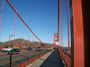
Crossing the Golden Gate Bridge, 9amThe weather was perfect, in the 60s and sunny. I rode over to Sausalito and continued on the bike path north, turning westward at Sycamore Ave, winding through some residential streets to get to Sequoia Valley Rd and then the Panoramic Highway.
What amazing views on this route, Sequoia and the Panoramic Hwy! There's climbing, but it's pretty gradual, nothing more than a 8-9 percent grade. The Panoramic Highway goes around Muir Woods, the park with the huge ancient redwoods, and the road itself goes through heavily forested areas.
The road has no shoulder, but on Friday the traffic was pretty light. The only downside was that the road was being repaved and for maybe 2-3 miles of downhill I was riding on roadway that had been milled down and was thus very bumpy and grooved, so I took it real slow.
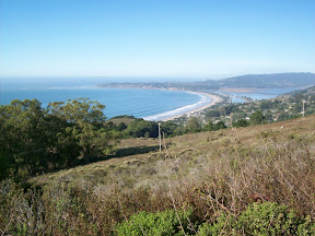
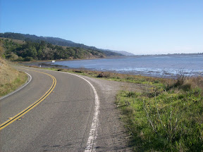
Looking north toward Stinson Beach from the Panoramic HighwayFinally the road work ended and I had a beautiful downhill into Stinson Beach. The views of the Pacific are spectactular. I turned north onto Shoreline Road (Route 1), and headed toward Port Reyes Station. The first part of this road is totally flat, right along the shore, and I cruised along at 19-20. Then the road turns away from the shore and becomes more rolling. It goes through a eucalyptus tree forest at one point, beautiful.
A flat bit of Rt 1 North of Stinson BeachAt Port Reyes Station I stopped at the Bovine Bakery, recommended to me by someone over at Bikeforums.net. I was feeling real good, the rental bike felt great, so I decided to try to make the ride into a century. To make sure I was back by dark I wanted the extra 20 miles to be as flat as possible, so I asked some cyclists who were at the bakery for suggestions, and they pointed me toward Bear Valley Rd all the way past Inverness where a big hill starts. So after I downed my pastry and bought some water and a banana at the grocery store across the street, I took off toward Olema.
I turned onto Bear Valley Rd. There are a couple of rollers at the start but it was really flat. After about 7 miles, just after the Inverness Inn, I hit the hill. I rode up it part of the way but decided to turn back when it looked to be pretty endless. I headed back, went through Olema and back onto 1.
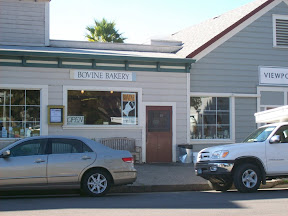
Bovine Bakery in Point Reyes StationAfter Stinson Beach Rt 1 began to climb, and the ride between Stinson Beach and Muir Beach is one of the most spectacular rides I've ever done. The highway is way up on the bluff overlooking the Pacific, and just to the right of the road are cliffs that go down 200-450 feet to the ocean. In some places there are guardrails, but in other there's nothing... Fortunately traffic was very light and so I was able to ride in the middle of the lane in those places. The road weaves inland along gullies and then back out to the shore, and the view is amazing.
Just past Muir Beach the road turns inland, and there's a great downhill. But in the middle of that downhill, I heard a loud pop and suddenly I realized my back tire had blown. When I got off the bike to check it out I saw that not only was the tube trashed, but the tire itself had a 5-6 inch rip in it. I called the place I'd rented from but they didn't seem to know where I was (I wasn't quite sure myself) and told me to call them back in 15 minutes.
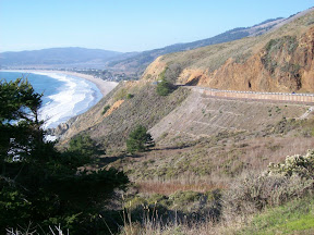
Looking north on Shoreline Hwy between Stinson Beach and Muir BeachFortunately, the cyclists in that area were incredibly helpful. Everyone who went by stopped, and one guy, after I explained my situation, actually went down to the nearby Pelican Inn, and came back to tell me he'd found another cyclist who had a truck and could bring me to a bike shop in Sausalito, about 6-7 miles away. I got to the Inn and the guy (I never did get his name) loaded my bike into his truck and we headed to Sausalito.
I got to see the rest of Rt 1 to Sausalito from the passenger seat of the truck; it is beautiful, and I'm disappointed I didn't get to ride it. But I got to the bike shop, thanked my ride and said goodbye. Turns out that the rim was really messed up too, so the bike rental place drove out to Sausalito with a new wheel and tire so I could complete the ride. At this point, almost 2 hours after the bike broke down, it was getting close to sunset, so I realized I wouldn't be able to make my century.
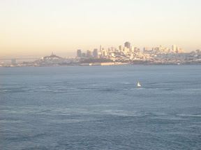
San Francisco at sunset, from Golden Gate BridgeI headed off toward San Francisco, crossing the Golden Gate at about sunset, with a beautiful view of San Francisco (the photo really doesn't do it justice), though lots of pedestrians slowed my last few miles. I got to the bike shop as dark descended.
I felt great, and ended up walking back to my hotel up Hyde St. The distance is only about 1.5 miles, but in the first 1/3 of a mile it climbs almost 300 feet, and the grade for much of that climb is upwards of 20 percent. My legs felt fine and I wasn't in the least bit winded. I realized I'm in better shape now than I was at age 25!
This was a fabulous ride. The weather was perfect, in the 60s and sunny, and such a nice change from the cold temps I've been biking in the past month. My legs felt great. The only downside is that the cyclometer that came with the bike only gave current speed and trip distance, so I had to keep track of time using the clock which only had minutes. So my speed is an estimate. Next time I'll bring one of my own cyclometers. And I'll rent from a real bike shop instead a place that just rents bikes to tourists...
The Finger Lakes region is beautiful, but Marin is beautiful in a whole different way. I'll definitely plan to come out this way again, even if only to do some riding!!
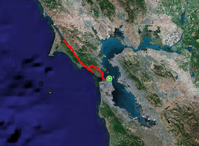
Route: San Francisco - Sausalito - Panoramic Highway - Stinson Beach - Point Reyes Station - Inverness - Muir Beach - [bike repair interruption] - Sausalito - San Francisco
Total distance: 88.33 miles
Ride time: about 5 hours, 54 minutes
Avg speed: about 14.9 mph
Total climb: about 4400 ft
Low point: 10 ft, San Francisco, Sausalito
High point: 1578 ft, on Panoramic Highway
Avg climb: 49.81 ft/mile
Total distance: 88.33 miles
Ride time: about 5 hours, 54 minutes
Avg speed: about 14.9 mph
Total climb: about 4400 ft
Low point: 10 ft, San Francisco, Sausalito
High point: 1578 ft, on Panoramic Highway
Avg climb: 49.81 ft/mile
